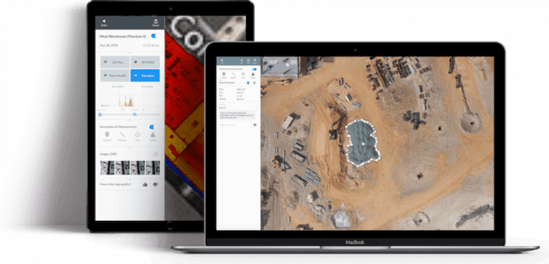
Orthomosaic Mapping /

Orthomosiac Mapping

Orthomosaic mapping enables a date-specific and highly detailed satellite view. Thousands of images are accurately stitched together to create the map, which then gives a ‘real-time’ overview of a whole site.

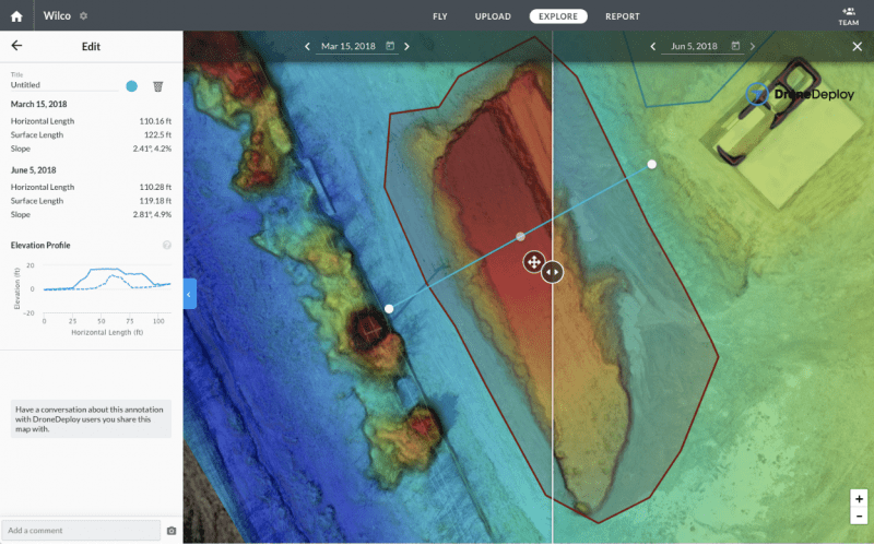
An orthomosaic map provides an accurate, detailed top-down snapshot of the conditions of any given area, which can then be used to monitor any and all site progress across the whole construction project, from pre-planning right through to the finished site. The key thing here is the ability to compare change over the weeks and months.

The tools we provide you enable quick and easy distance, profile and volume measurements alongside annotations and object counting.

A laptop and a tablet show examples of orthomosaic mapping on screen

Have a project in mind?

Fill in your details and one of our team will be in touch.

    Topographical Outputs

    Topographical mapping is a technique that uses a colour scale to demonstrate accurate graphic representations of an area of earth. We are able to create digital terrain & surface models from data collected during this process. This could be from either a photogrammetry or lidar tasking.

    This method is ideal when it comes to construction site planning. Easily work out and view elevation changes throughout your site, helping to provide the important information for cut and fill operations.

    A computer screen shows a topographical map

    Our Equipment

    We have a range of high tech UAV and sensor equipment to get the job done. Our flagship UAV the DJI Matrice 300 RTK is unmatched in its safety features, technology and versatility being able to carry multiple sensors. The connection to an RTK Base station allows us to gather MM accurate results and helps the platform hold position even in the harshest of environments. This drone has as a minimum a double redundancy on all of its critical flight systems and can even maintain flight on 3 propellers. We are able to operate at night, heavy wind, rain and snow making it an ideal response tool in those emergency situations.

    Click below to find out more about this system and others that we use.

    DJI H20T /

    Multi-sensor payload combining a wide camera, 200x zoom camera, Radiometric Thermal camera & Laser Range Finder. The most versatile UAV sensor to date for commercial inspections.

    DJI P1 /

    A 45 MP full frame photogrammetry sensor is a 3d modelling and inspection weapon. Boasting a new super fast global mechanical shutter it allows us to snap images every 0.7 seconds even on the move.

    Z15 Spotlight /

    A 10,200 lumen LED spotlight that matches the movement of the primary camera sensor allowing us to capture clear RGB inspection imagery at night and low light situations.

    DJI L1 /

    A Livox Lidar module, a high-accuracy IMU, and a RGB camera with a 1-inch CMOS sensor. The L1 forms a complete lidar solution efficiently capturing complex structures and landscapes.